
Topographical Survey

A topographical survey, also known as a land survey or contour survey, is a detailed mapping process that captures the natural and man-made features of a particular area of land. Unlike boundary surveys, topographical surveys focus on elevation, terrain, and visible physical features, offering vital data for planning, engineering, and development projects. What is […]
Hydrography Survey
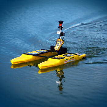
A hydrographic survey is the science of measuring and describing physical features beneath water bodies—rivers, lakes, seas, and oceans. It plays a crucial role in navigation safety, marine construction, environmental monitoring, and coastal management. Hydrographic Survey Hydrographic surveying involves collecting data about: Using specialized equipment, surveyors produce nautical charts, depth maps, and 3D models of […]
Drone /UAV Survey
In the world of modern surveying, Drone or UAV (Unmanned Aerial Vehicle) Surveys are transforming how we capture data from the sky. These aerial systems offer high-speed, high-accuracy surveying solutions for a wide range of industries—from construction to agriculture, urban planning to disaster management. What is a Drone/UAV Survey? A Drone Survey involves using UAVs […]